Honoring the Best of Consulting Engineering since 1989.
2022 Award of Excellence
Owner: Naut’sa mawt Tribal Council | Vancouver Island, BC
About the Project
First Nation communities on Vancouver Island are vulnerable to coastal storms and tsunamis, as well as to climate-induced sea level rise. Indigenous Services Canada (ISC), First Nation Adapt, and Naut’sa mawt Tribal Council are working to assess the level of vulnerability.
Parsons was engaged to deliver the Vancouver Island Coastal Vulnerability Study, to model the effects of storms and tsunamis, identify inundation limits and water depths, and to create vulnerability assessments for individual communities.
Prior to this project there was minimal coastal hazard data available for planning critical infrastructure investment. There was no existing model capable of generating the results needed, so Parsons developed and built a first-of-its-kind hydrodynamic model with a very large area of 2,500 km x 2,100 km to simulate tsunamis and large storm events, combined with sea level rise, that can be used with confidence to plan for infrastructure replacement and renewal.
Our scope for the project was to develop a large numerical hydrodynamic model to simulate tsunamis and storm events on Vancouver Island; visit each community to speak to elders and residents, view existing infrastructure, and survey the foreshore; simulate combinations of storm events and tsunamis, incorporating sea level rise, to determine impacts to coastal communities; and to prepare vulnerability reports to identify the flood inundation hazard in a simple graphical format useable by each community.
Understanding the potential inundation limits for storms and tsunamis, with sea level rise, enables informed decisions on infrastructure investment and economically robust capital planning. The vulnerability reports are now being used by communities to evaluate mitigation and adaptation options, and to develop programs and funding requests for replacement of vulnerable infrastructure. The model and vulnerability reports are also an engagement and educational tool for future community leaders.
Approach
Initial site visits (virtual as necessary due to the pandemic) were conducted for each community to identify infrastructure at risk and meet with elders and residents to gather historical information.
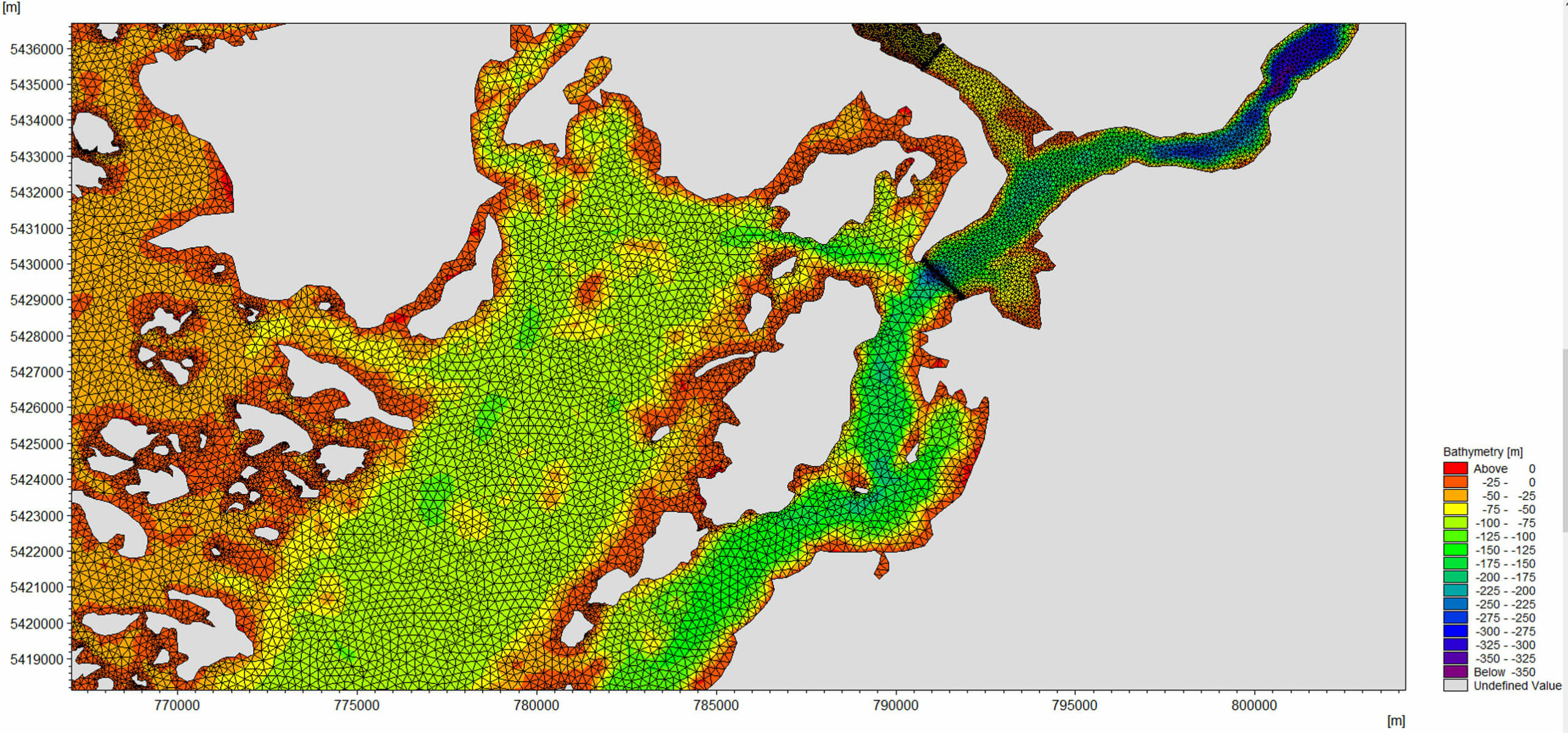
Bathymetric and topographic information was collected to incorporate into the model. A flexible finite-element mesh for the bathymetry was developed using a coarse mesh in the deep ocean and a very dense mesh closer to each site to generate more accurate local simulations. This results in a new standard of detail and accuracy in simulating coastal tsunami and storm impacts.
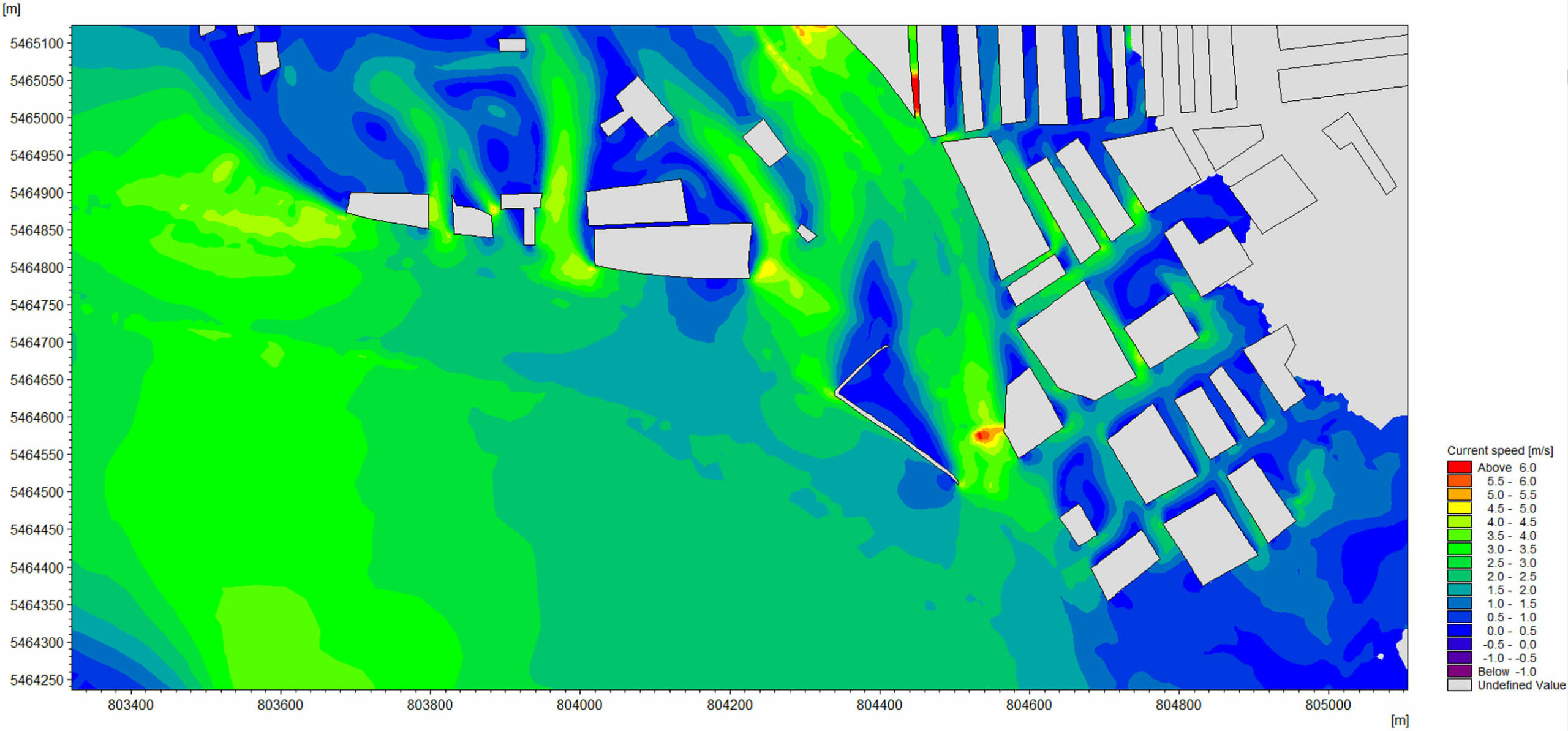
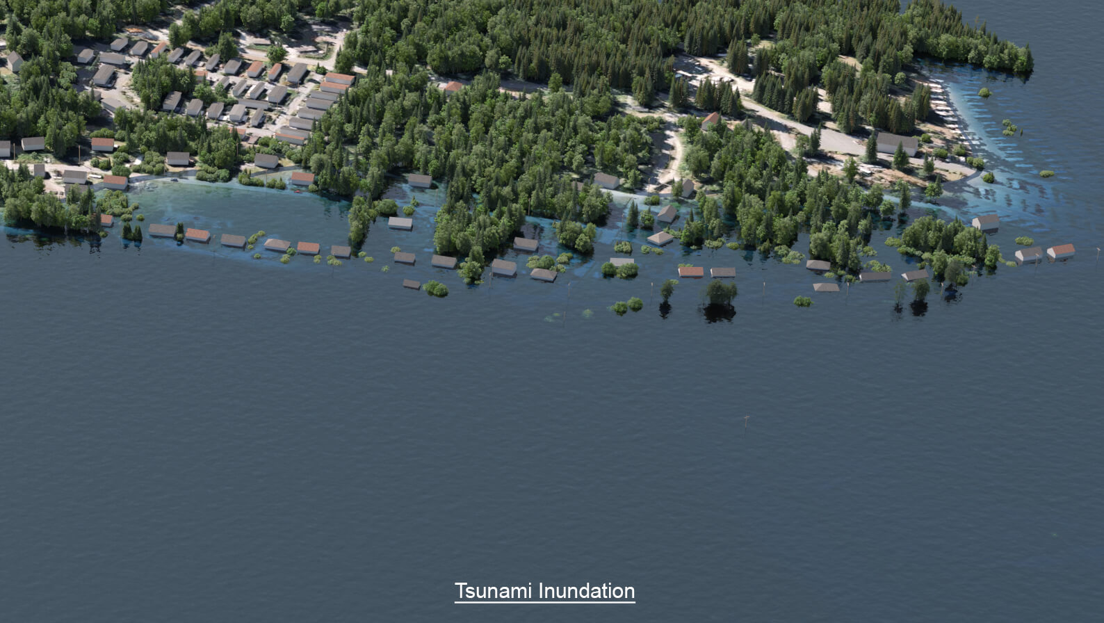
The overall hydrodynamic model was created using DHI MIKE 21 software as a platform. Detailed local models were created for each community and superimposed onto the overall model. The model is unique in covering a very large ocean area to fully simulate tsunami and storm propagation and being detailed enough to produce large-scale inundation hazard maps for individual communities. The modelling was technically complex, due to both the size of the domain and the finite-element mesh density. Model output gives the extent and depth of inundation from tsunamis and large storms. Vulnerability reports were prepared for communities to describe existing infrastructure, summarize historical information, explain the assumptions and decisions made for the modelling, and to show inundation in a 3D photo-realistic graphical format. This creates a useable tool for infrastructure planning and climate change adaptation.
Results
Tsunami and storm modelling including sea level rise shows inundation of several metres above present-day and effects on infrastructure. Graphical presentation of the Vulnerability Reports makes complex modelling into a useable planning tool. High-resolution 3D photo-realistic graphics show inundation limits in a relatable way. Videos show the ebb and flow of waves over time. Understanding the coastal hazard enables communities to plan and seek funding for climate change adaptation measures.
Service(s) Provided
1. Visit First Nation communities to identify infrastructure at risk and meet with elders and residents to gather historical information.
2. Perform topographic and bathymetric surveys.
3. Develop a numerical hydrodynamic model to simulate tsunamis and storm events incorporating climate change.
4. Prepare vulnerability reports to identify the flood inundation hazard in a simple graphical format useable by each community.
Project Team (Consultants)
Bazett Land Surveying
Robin Fenn Consulting
Go back to projects in
View other projects from

Proudly presented by
Stay in touch with us
Subscribe to our mailing list!
Organization
Connect