Honoring the Best of Consulting Engineering since 1989.
Owner: Strathcona Regional District | Campbell River, BC
About the Project
Northwest Vancouver Island is characterized by its natural beauty and rich history. With the Pacific Ocean to the west, this region is exposed to tsunami hazards from local sources, such as the Cascadia Subduction Zone, and distant sources, such as the Aleutian Islands Subduction Zone in Alaska. Recent major tsunamis around the world have demonstrated the potential for widespread destruction and danger.
The Strathcona Regional District (SRD) in partnership with the Ka:’yu:’k’t’h’/Che:k:tles7et’h’ First Nations and Nuchatlaht First Nation undertook a Tsunami Flood Risk Assessment with help from Northwest Hydraulic Consultants (NHC), Ocean Networks Canada (ONC), and and NSC Seismic Consultants. The goal of this project is to understand tsunami risks on the northwest coast of Vancouver Island, by using tsunami mapping and drawing upon community experience and indigenous knowledge.
The vast study area expands south from Yuquot to Cape Scott to the north (Figure 1), and includes the communities of Gold River (Port), Tahsis, Zeballos, and Port Alice, as well as several Indigenous communities including the Ka:’yu:’k’t’h’/Che:k:tles7et’h’, Nuchatlaht, Ehattesaht Chinehkint, Mowachaht / Muchalaht, and Quatsino First Nations. The study area covers the many historic community locations, sacred sites, fishing and hunting areas, shellfish harvesting sites and old village sites. Because the assessment covers such a large geographical area, the project has been divided into two phases. (Figure 1). Phase I, which focuses on the communities connected to Kyuquot Sound, Esperanza and Tahsis Inlets, began in the summer of 2020. Detailed tsunami inundation maps were completed and published online in the summer of 2021 (www.srd.ca/tsunami-mapping). Phase II will begin in 2022 and includes the communities in Quatsino and Nootka Sounds.
For the very first time this project provides a broad and quantitative measure of the tsunami hazard on this particularly exposed portion of the BC coast.
Approach
The project focuses on the importance of “making space at the table for everyone” in disaster risk reduction and management. It highlights how Indigenous communities living at the forefront of tsunami risk have fostered disaster resilience and knowledge over millennia. Our approach leverages on Indigenous knowledge and community engagement combined with scientific tsunami modelling and mapping. This synergetic approach seeks to strengthen outcomes and their lasting adoption by communities. To learn from and share the experience, knowledge, and history of local communities, a project webpage, an online public survey, and several virtual public engagement meetings were completed. An Advisory Group was consulted throughout the project to guide the project team and promote the exchange of knowledge. A digital elevation model (DEM) was developed based on bathymetric and light detection and ranging (LiDAR) topographic surveys. Two tsunami scenarios were simulated, one from the nearby Cascadia Subduction Zone and another from the more distant Aleutian Islands Subduction Zone in Alaska. Local tsunami flood maps were developed for 25 priority areas (Figure 2) and ocean conditions such as maximum amplitude and current speed were mapped across the study area. A risk assessment was completed to identify potential hazards to life and critical infrastructure such as roads and buildings, strengthening the four phases of emergency management: mitigation, preparedness, response, and recovery.
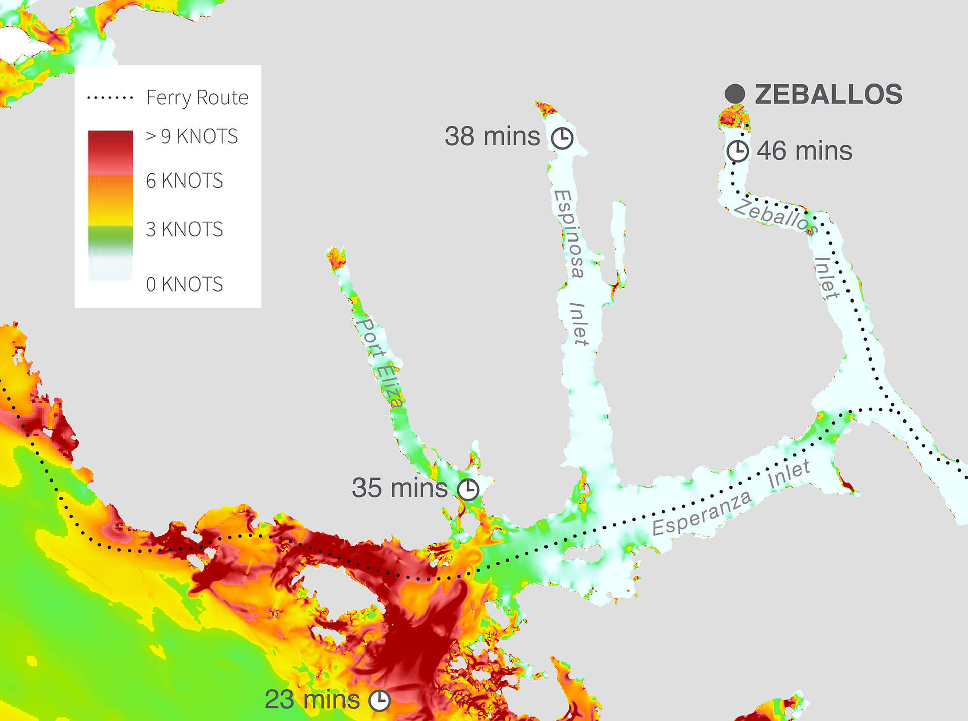
Results
Maps were created that show the tsunami hazards, including the extent of how flooding affects communities (Figure 3) and how fast current speeds will put mariners out on the water at risk (Figure 4). Results also include tsunami arrival times, which on the open west coast of Vancouver Island could be within 20 minutes after an earthquake at the Cascadia Subduction Zone. Further inland, towards the end of the study area’s many inlets, the arrival of the tsunami could be up to 40-50 minutes.
Service(s) Provided
Indigenous and community engagement
Bathymetric and topographic surveys
Tsunami modelling and mapping
Risk assessment
Project Team (Consultants)
Ocean Networks Canada Society
NSC Seismic Consultants
Project Team (Contractors)
Terra Remote Sensing Inc.
McElhanney
Go back to projects in
View other projects from


Proudly presented by
Stay in touch with us
Subscribe to our mailing list!
Organization
Connect